Curiosity entered the the area dubbed Yellowknife Bay on sol 125 (Dec. 12) and after a few quick dashes around made a beeline to the outcrop on the north side of the depression, where it has been parked for several days as it looks for a promising rock formation to test out the drill at the end of its robotic arm.
Here’s the fisheye HAZCAM view:

And the NAVCAM view:

The MAHLI camera (hand-lens imager) took some closeup views yesterday afternoon. Here are a couple of them, with some post-processing (white balance, contrast, etc.):


Might this be more of the conglomerate-type rock that was seen near the landing site, that tipped off the Mars scientists that the general area once had flowing water? So far they haven’t said anything publicly about what they’re seeing at Yellowknife Bay.
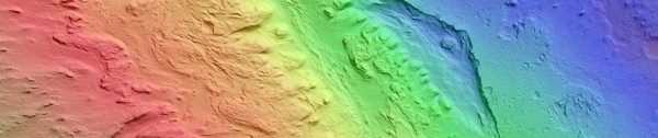
Under the principle that water flows downhill, the area where these photos were taken would be a good candidate to find water-lain deposits–it’s nearly 19 meters (62 feet) lower than the landing site:

The “riverbed” conglomerate (“Hottah”) was found on Sept. 15 at the elevation and drive distance shown by the red dot above.
Browse the latest raw images from Curiosity at CuriosityMSL.com
