Monthly Archives: August 2012
RAW image browser
I made a web page that conveniently lists the latest raw images received from Curiosity. Here’s a screen shot: Check it out at: Curiosity MSL raw image browser
MSL Almanac
Here’s a calendar currently up through Sep. 30 that shows the rise and set times for the sun, earth, MRO, ODY and MEX at the MSL landing site.
Gale slope map in Google Mars
Tesheiner at unmannedspaceflight.com took my slope map and tiled it for use with Google Earth (actually Google Mars). To try it out, right click and save this kml file: Gale slope map KML file Then open it with Google Earth. … Continue reading
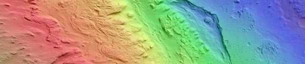
MSL landing site slope map, V2
Rover driver Paolo Bellutta notes on the forum at unmannedspaceflight.com that JPL uses a three-color scheme in making their slope maps for traversability analysis: 0°-10°: grayscale — very little slip on any terrain 10°-12.5°: blue — some slip on sand, little slip on bedrock … Continue reading
Terrain at the MSL landing site
The good people working on the High Resolution Imaging Science Experiment (HiRISE) at the University of Arizona have provided several digital terrain model (DTM) files of the expected MSL landing site at Gale Crater. These files give, at a resolution … Continue reading
