Camera context for MSL images

Curiosity has taken over 30,000 images so far in its first four months on Mars. The rover has covered about 700 meters of terrain to date and it can be a challenge to figure out just where a given image was taken from in Gale Crater. The official NASA raw images website doesn’t provide information on where the images were taken or in what direction the camera was pointing.

Luckily, such information is available, albeit with the help of some tricky software, from the NASA Navigation and Ancillary Information Facility (NAIF). NAIF data files for MSL are updated roughly once a day in an unofficial directory on the NAIF website. I updated the raw image browser at CuriosityMSL.com to have a “map it” link next to each image that gives a side-by-side view of a given image next to a map of the camera context:

mslmap

link

A red wedge from the camera position on the map shows the approximate field of view for the given camera. The map can be panned/zoomed. The highest resolution is 4 meters per pixel from the MRO HiRISE camera. Zooming out eventually brings in the MRO CTX camera and Google Mars imagery at lower resolutions.

For a map view of Curiosity’s track from the landing site to the current position, see this link:

http://curiositymsl.com/rovermap1.html 

Posted in Uncategorized | 2 Comments

Curiosity at Yellowknife Bay

Curiosity entered the the area dubbed Yellowknife Bay on sol 125 (Dec. 12) and after a few quick dashes around made a beeline to the outcrop on the north side of the depression, where it has been parked for several days as it looks for a promising rock formation to test out the drill at the end of its robotic arm.

Here’s the fisheye HAZCAM view:

FLA_409212417EDR_F0051662FHAZ00206M_

And the NAVCAM view:

NLA_409211753EDR_F0051662NCAM00207M_

The MAHLI camera (hand-lens imager) took some closeup views yesterday afternoon. Here are a couple of them, with some post-processing (white balance, contrast, etc.):

sol132sol132-2

Might this be more of the conglomerate-type rock that was seen near the landing site, that tipped off the Mars scientists that the general area once had flowing water? So far they haven’t said anything publicly about what they’re seeing at Yellowknife Bay.

Under the principle that water flows downhill, the area where these photos were taken would be a good candidate to find water-lain deposits–it’s nearly 19 meters (62 feet) lower than the landing site:

elevation122012a

The “riverbed” conglomerate (“Hottah”) was found on Sept. 15 at the elevation and drive distance shown by the red dot above.


Browse the latest raw images from Curiosity at CuriosityMSL.com

Posted in Uncategorized | Leave a comment

RAW image browser

I made a web page that conveniently lists the latest raw images received from Curiosity. Here’s a screen shot:

Check it out at: Curiosity MSL raw image browser

Posted in Uncategorized | Leave a comment

MSL Almanac

Here’s a calendar currently up through Sep. 30 that shows the rise and set times for the sun, earth, MRO, ODY and MEX at the MSL landing site.

Posted in Uncategorized | 5 Comments

Gale slope map in Google Mars

Tesheiner at unmannedspaceflight.com took my slope map and tiled it for use with Google Earth (actually Google Mars). To try it out, right click and save this kml file:

Gale slope map KML file

Then open it with Google Earth. You will be asked to switch the view to Mars and then you should be able to zoom in on the Gale Crater area with the slope map overlaid.

Recently Google has put high-resolution HiRISE imagery of Gale Crater on standard Google Mars, which tends to overlay the slope map. To disable that layer, uncheck “Rovers and Landers” in the Layers area on the left of the screen.

Here’s a Google Mars view of a candidate traverse:

Posted in Uncategorized | Leave a comment

MSL landing site slope map, V2

Rover driver Paolo Bellutta notes on the forum at unmannedspaceflight.com that JPL uses a three-color scheme in making their slope maps for traversability analysis:

0°-10°: grayscale — very little slip on any terrain

10°-12.5°: blue — some slip on sand, little slip on bedrock

12.5°-25°: green — no traverse on sand, some slip on bedrock

25°-90°: red — no traverse

Accordingly, I remade my slope map to use this color scheme. Also, I cropped down the image to make it readable by more image programs:

MSL slope map (26600×27664) — 153 MB (right click to download)

Posted in Uncategorized | Leave a comment

Terrain at the MSL landing site

The good people working on the High Resolution Imaging Science Experiment (HiRISE) at the University of Arizona have provided several digital terrain model (DTM) files of the expected MSL landing site at Gale Crater. These files give, at a resolution of one meter per pixel, the elevation of the Mars surface shown in the corresponding visual images taken by the HiRISE camera.

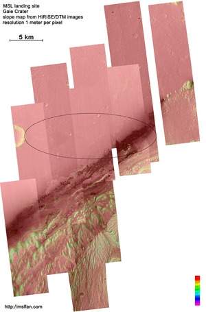
Neighboring pixels can be compared in elevation to get an estimate of the slope of the terrain at each point, in degrees, where 0° is horizontal and 90° is vertical. Here’s the result of such a process applied to a mosaic of all the publicly available DTM models for the landing site:

MSL landing area slope map (31000×47000) — 213 MB jpg file (right click to download)

MSL will in all probability land in the ellipse drawn on the map above. Slope in the map is color-coded as follows:

It’s important to know the slope because the practical limit for the Curiosity rover on its drives is 25°. Thus it can be seen that areas of the map colored red, orange or yellow are generally traversable by Curiosity (at least on the basis of slope), while the other colors green, blue, indigo and violet are increasingly off-limits.

If the full-res image is larger than you want to deal with, here’s a downsampled version at 4 mpp:

MSL 4mpp slope map (7750×11750) — 17 MB (right click to download)


Posted in Uncategorized | Leave a comment

MRO looks at Curiosity

As MSL enters Mars’ atmosphere, the Mars Reconnaissance Orbiter will attempt to photograph it, along with receiving MSL’s radio signals for later rebroadcast to Earth.

Here’s an animation I made showing the predicted view of MRO’s HiRISE camera, using orbit and camera-pointing data published by NASA on their Navigation and Ancillary Information Facility (NAIF) website.

The background music is excerpted from Telegraphic, by Axoe.

Posted in Uncategorized | Leave a comment

HiRISE Mosaic of MSL landing site

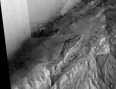
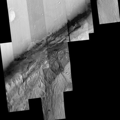
MSL will land in the relatively flat upper left landscape shown in this mosaic of images taken by the HiRISE camera aboard the Mars Reconnaissance Orbiter. From there, the rover will travel to the more rugged landscape to the lower right (dubbed Mount Sharp, in the center of Gale Crater). The resolution of this image is 1 meter per pixel.

Full size 13000×10000 pixels — 40MB (right click to save)

Here’s a mosaic of a significantly larger area, showing the individual HiRISE image strips covering the relevant north section of Gale Crater that contains MSL’s “landing ellipse”:

Full size 30017×46254 pixels — 240 MB (right click to save)

Turns out a lot of image programs (e.g. Photoshop) can’t display images greater than 30,000 pixels or so on a side. GIMP (free software) can handle the file.

Here’s a 30000×30000 crop of the mosaic that should be viewable by Photoshop:

Full size 30000×30000 pixels — 161 MB  (right click to save)

Posted in Uncategorized | 4 Comments

Hello Mars!

A blog about the Mars Science Laboratory mission to Mars, scheduled to land August 5, 2012 at 10:18 pm Pacific Time.


Posted in Uncategorized | Leave a comment