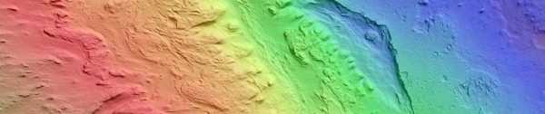
Rover driver Paolo Bellutta notes on the forum at unmannedspaceflight.com that JPL uses a three-color scheme in making their slope maps for traversability analysis:
0°-10°: grayscale — very little slip on any terrain
10°-12.5°: blue — some slip on sand, little slip on bedrock
12.5°-25°: green — no traverse on sand, some slip on bedrock
25°-90°: red — no traverse
Accordingly, I remade my slope map to use this color scheme. Also, I cropped down the image to make it readable by more image programs:

MSL slope map (26600×27664) — 153 MB (right click to download)
